Case study
Introduction and objectives
A magnetic survey was undertaken at the Late Prehistoric-period Kutoyis Bison Kill Site (24GL366), located in the Blackfeet Indian Reservation, north-central Montana. Magnetic survey was used as a non-destructive technique to map bison processing features and to prioritize areas for future excavation and understand site patterning. The magnetic survey was part of a Program of research at the site directed by Maria Nieves Zedeño of the University of Arizona. The magnetic survey was performed by Archaeo-Physics. Participants in the Tribal Archaeological Monitors Training Program assisted with magnetic data collection, as well as conducted excavations concurrent with the magnetic survey.
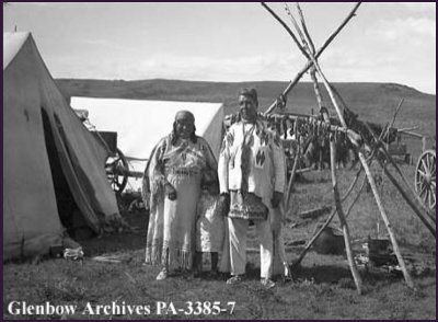
Siksika (Blackfoot, Alberta) family camp; note the outdoor hearth and racks for drying meat. 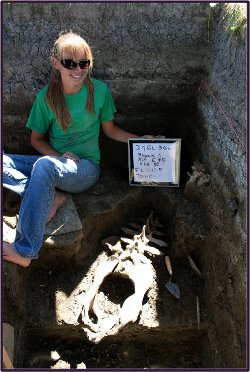
Exposed “boss rib” bone on the third of four excavated cultural surfaces.
Among Native American hunters of the northwestern Plains, bison processing was generally accomplished in various stages, including butchering, skinning, defleshing, meat roasting and boiling, marrow and bone fat rendering, drying or smoking of thinly cut meat, and pemmican production. These activities were labor intensive, particularly after communal hunts that yielded large numbers of carcasses(1). Whether located in the immediacy of a kill site or at a distance from it, processing camps associated with communal bison hunts incorporated a number of features to process large quantities bison products efficiently, including sufficient space to work on the carcasses and stretch the hides(2), abundant running water, firewood, stones suitable for boiling, and raw materials for manufacturing tools. Because fire was a key element in bison processing, thermal features may be expected to be intrinsic to the patterning of processing camps.
The Kutoyis site (AD 1050-1630) was used repeatedly by ancestral Blackfoot hunters during the communal hunting season. In addition to three stratified, burned bonebeds located on the slope immediately below the jump, there is a butchering and defleshing area composed of four (and perhaps five) discrete cultural surfaces with unburned, articulated and disarticulated bone. Each of these surfaces was preserved and buried under the Two Medicine River floodplain(3).
Before 2010, no fire-dependent bison processing features were uncovered from systematic excavations and only one faint burned clay feature was identified in shovel tests. It was expected that if a processing camp was indeed located upwind from the butchering area, it would be likely buried under the broad alluvial plain to the west of the jump.
Magnetic survey methods
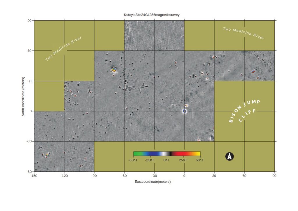
Magnetic surveys map local variations in the earth’s magnetic field, most importantly distortions caused by subsurface materials. Materials transported or altered by human activity may differ in their magnetic properties and patterning from their natural surroundings. Magnetic survey is useful in archaeology when these anthropogenic distortions of the geomagnetic field contrast sufficiently from their surroundings to be physically detected and interpreted as a form of material culture. The chief limitation in the use of magnetic survey is that non-archaeological phenomena can overwhelm or complicate the interpretation of the archaeological record. The magnetic properties of archaeological (and non-archaeological) materials are too complex a subject to be treated here, but it may be useful to distinguish between monopolar and bipolar anomalies. Monopolar anomalies appear as either a positive or negative deviation fro their surroundings, while bipolar anomalies have a positive and negative pole. The magnetic survey was performed using a Geoscan Research FM256 magnetic gradiometer. This instrument measures only local gradients in the geomagnetic field, effectively filtering out large scale and very deep phenomena, showing localized phenomena as positive and negative deviations from the local mean, which is recorded as zero. Data were collected in parallel transects across the site spaced at 0.5 m intervals. Eight samples were recorded per meter along each transect, resulting in a data sample density of 16 samples/m2.
Magnetic survey targets
The principal anticipated survey targets were prehistoric hearth features. For the purposes of magnetic data interpretation the term hearth is used broadly, and may include domestic hearths and specialized features associated with bison processing or other activities. The magnetic expressions of hearth features tend to be broadly similar, appearing in survey data as a weak to moderately-strong positive anomaly.
Other phenomena may sometimes cause anomalies similar to those associated with prehistoric hearths, including modern metal, some types of rock, and tree burns. These can usually be distinguished from features of interest, but their range of expression may overlap that of hearth features.
Other features of interest that may be detected magnetically include: organically enriched features, such as middens and butchering areas; pit features; concentrations of burned or unburned rock; and stone rings or other architectural features(4).
Environmental considerations
The terrace upon which the site is located is generally a very favorable environment for magnetic survey. The low-energy alluvial deposits provide a very uniform background against which cultural features may be readily distinguished. Two factors that complicate interpretation are sandstone from the outcrop at the southern edge of the site (part of which forms the jump itself), and the presence of a moderate amount of modern metal. Although the sandstone is only weakly magnetic, it was found to appear similar to hearth features in its magnetic expression (this is not true of sandstones generally). The greatest concentration of sandstone appears near the base of the cliff. Because of this, the magnetic survey avoided the cliff base, giving preference to areas more likely to be interpretable.
Although little modern metal was observed on the surface, it is apparent from survey data that moderate concentrations of ferrous metal are present within the survey area. These typically appear as strong bipolar anomalies (having positive and negative poles). They can usually (but not always) be distinguished from hearth features based on their appearance. (mouse over image to display interpretations)
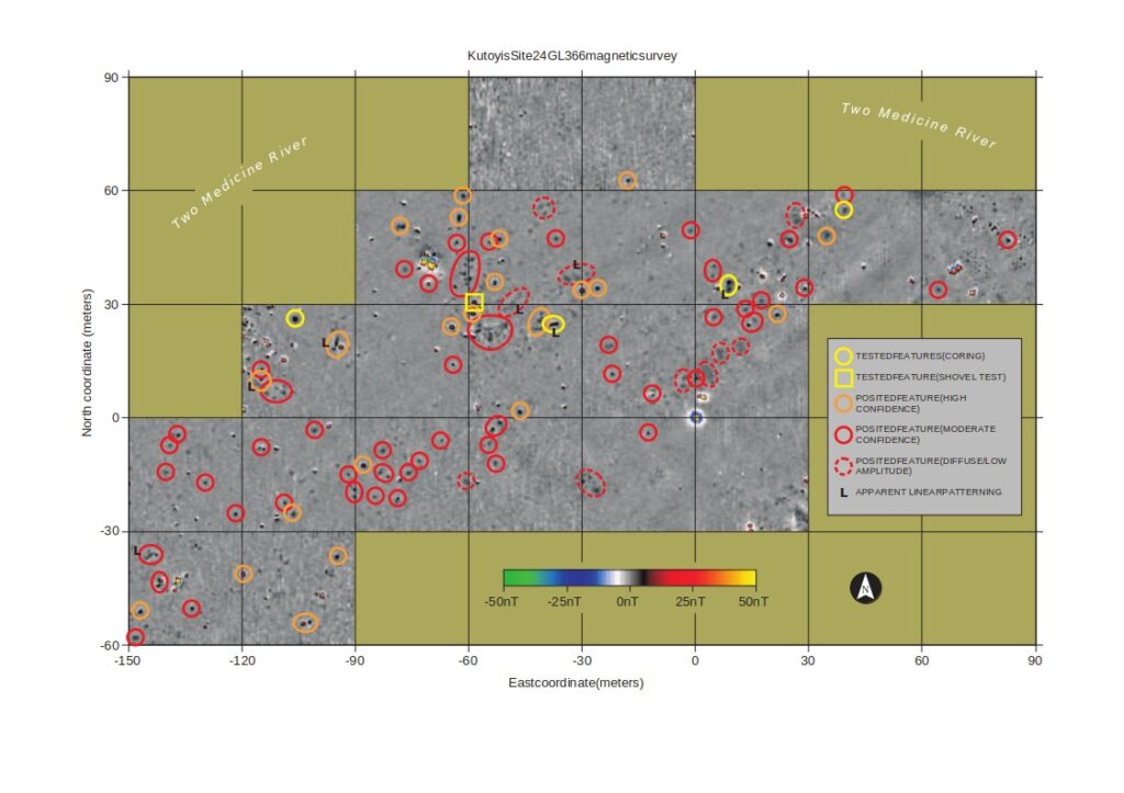
Roughly 100 suspected features and activity areas have been marked on the interpretive map. Many more possible features are expressed, but only those thought to have the highest potential are marked. Most of these are thought to be hearths, although features composed of concentrations of rock and a mix of thermally altered and organic material can appear very similar.
Some of these features (examples are marked with an L) appear to have a linear patterning. This distinctive patterning may be associated with a specialized feature type.
Low-amplitude, diffuse magnetic highs (indicated by a dashed red line) may express organically enriched features (possibly deposits of butchering residues). An alternative interpretation is that they are an expression of more deeply buried hearth features, whose depth may be an indication of greater age.
Five anomalies posited as cultural features (indicated by a yellow circle) were tested by sampling with a 1” Oakfield hand core. All of these tests produced cultural materials, including charcoal, bone, ash, and oxidized soil. An equal number of cores sampling non-anomalous areas showed natural soil profiles. One of the cored features was further tested with a 50-x-50 cm shovel test, confirming its identification as a prehistoric thermal feature.
Interpretation and testing
At this time, interpretation of these magnetic survey results are still in a preliminary phase. Initial interpretations were founded on analogy with previously surveyed sites and reasonable models of feature composition. These have been broadly confirmed by initial testing, but interpretations remain both conservative and rather general in their nature. This level of interpretation forms a basis for generating hypotheses about site patterning and function, and also as a means of targeting features and activity areas for excavation.
Key to interpretations (mouse over image to view):
- Roughly 100 suspected features and activity areas have been marked on the interpretive map. Many more possible features are expressed, but only those thought to have the highest potential are marked. Most of these are thought to be hearths, although features composed of concentrations of rock and a mix of thermally altered and organic material can appear very similar.
- Some of these features (examples are marked with an L) appear to have a linear patterning. This distinctive patterning may be associated with a specialized feature type.
- Low-amplitude, diffuse magnetic highs (indicated by a dashed red line) may express organically enriched features (possibly deposits of butchering residues). An alternative interpretation is that they are an expression of more deeply buried hearth features, whose depth may be an indication of greater age.
- Five anomalies posited as cultural features (indicated by a yellow circle) were tested by sampling with a 1” Oakfield hand core. All of these tests produced cultural materials, including charcoal, bone, ash, and oxidized soil. An equal number of cores sampling non-anomalous areas showed natural soil profiles. One of the cored features was further tested with a 50-x-50 cm shovel test, confirming its identification as a prehistoric thermal feature.
It is very likely that some anomalies identified as possible features are in fact of natural or modern/historic origin. It is also very likely that prehistoric cultural features are present that that have not been detected or identified as such. Many weak or poorly-defined anomalies that are unmarked may indeed express cultural patterning, but are perhaps more likely to be of natural origin. Very strong anomalies that are not marked are thought most likely to be caused by modern/historic metal, although prehistoric hearths may exceptionally have a similar magnetic expression.
In relation to the natural features on the landscape, the survey area lies between the base of the cliff and bone bed (in the unsurveyed are in the southeast portion of the map) and the riverbank to the northwest. In their general distribution, most of the posited features are found in a broad arc parallel to the riverbank, and at some distance (and upwind) from the jump site and principal bone bed.
Conclusions
Cultural interpretations of geophysical data are necessarily speculative, especially without extensive subsurface testing. Nevertheless, the results of the magnetic survey of the Kutoyis Bison Kill Site are compelling, and have given insights into intra-site patterning that could probably not have been gained by other means. Preliminary testing confirms that:
- Large numbers of features are likely to be present, and it is supposed that these are largely associated with bison processing.
- The large number and extent of posited cultural features suggest very large communal activities or repeated use, or both.
- The distribution of features in relation to the kill site and the river may suggest testable hypotheses about the organization and operations related to communal bison hunting and processing.
- Based on testing and analogy with other sites, a large percentage of the features are thought to be burned, and thus likely to yield materials datable by radiocarbon and archaeomagnetic methods. The potential for targeting datable features suggests that very high temporal resolution might be achieved in future research.
The high level of positive results in preliminary testing (100% confirmation of posited features) suggests that further testing and excavation are likely to produce positive data that will inform further interpretation of the geophysical data and suggest further testable hypotheses.
See also: New Technologies (and Tires) Reconstruct Ancient Bison Hunts (UA News)
UPDATE:
Magnetic survey results were used to guide formal excavation during the 2011 field season, allowing researchers to accurately target bison processing features for excavation and giving insight into unexcavated portions of the site. 2011 excavation results are still under analysis, but will be posted as they become available
This page is based on: Magnetic survey at the Kutoyis Bison Kill Site, Montana (Geoffrey Jones (Archaeo-Physics), Maria N. Zedeño, William Reitze, Jesse Ballenger, and Benjamin Curry (University of Arizona.)). Presented at the 2010 Plains anthropological conference Plains Anthropological Society Conference, Bismarck, ND, October 6-1-, 2010
Notes:
1. Verbicky-Todd, Eleanor 1984 Communal Buffalo Hunting among the Plains Indians: An Ethnographic and
Historic Review. Archaeological Survey of Alberta Occasional Paper No. 24.
Alberta Culture, Historical Resources Division, Edmonton.
,176
2. Brink, Jack W. 2008 Imagining Head-Smashed-In, Athabasca University Press, Edmonton, Canada, p. 180.
3. Zedeño, M. N., J. Ballenger, W. Reitze, N. Laluk, and R. Johnes 2010 The Kutoyis (Two Medicine) Bison Hunting Complex, Two Medicine River, Blackfeet Indian Reservation, Glacier County, Montana. Final Report of the Kutoyis Archaeological Project (KAP) National Park Service Tribal Heritage Grant 30-07-NA-3015 2007-2009. Bureau of Applied Research in Anthropology, University of Arizona, Tucson.
4. Magnetic survey of prehistoric northern Plains campsites is discussed more fully in: Jones, Geoffrey; Gene Munson 2005 Geophysical Survey as an Approach to the Ephemeral Campsite Problem: case studies from the Northern Plains. Plains Anthropologist, Vol. 50, No. 193, pp. 31-43.
For a more general overview, see: Aspinall, Arnold; Chris Gaffney, Armin Schmidt 2008 Magnetometry for archaeologists. Altamira, Lanham, MD.