Cemeteries are a special subject in archaeology, not only because they are more stringently protected by law than other types of sites but also because of cultural respect for the dead and for their descendant communities. The study of cemeteries, whether for preservation, restoration, or research, must generally avoid invasive or destructive methods. Because they are non-invasive, geophysical methods are of particular importance in cemetery studies.
Archaeo-Physics has conducted geophysical investigations of numerous cemeteries throughout the United States. The objective of these investigations was to locate both marked and unmarked burials within known cemetery boundaries, as well as locate and define cemetery boundaries.
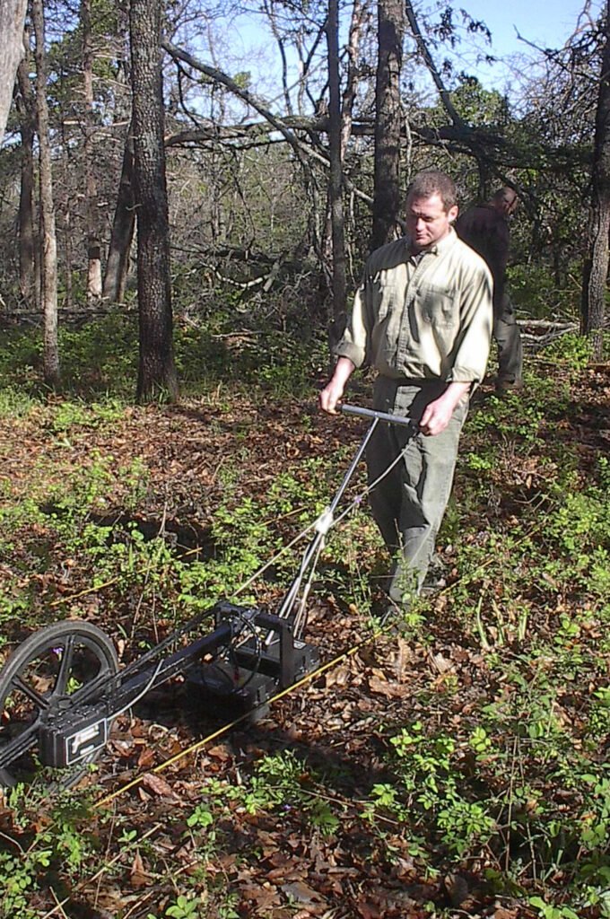
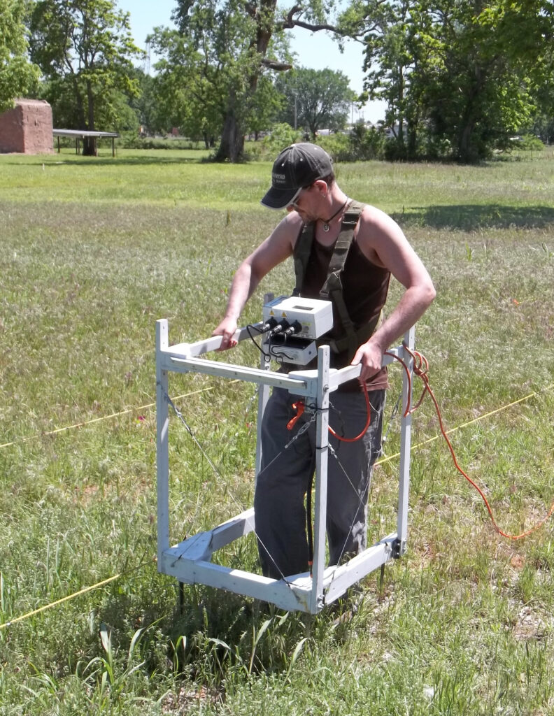
These investigations consisted primarily of ground penetrating radar (GPR) surveys, although electrical resistance and magnetic surveys are often effective where field conditions do not favor GPR.
Ground Penetrating Radar
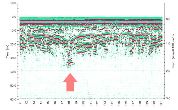
GPR has been successfully used to locate both marked and unmarked human burials in historic and precontact cemeteries and in forensic work. Graves may be detectable with GPR based on disturbed soil associated with the grave shaft, reflections associated with bones, coffins, grave goods, clothes and the detection of breaks in the natural soil stratigraphy. The location of disturbed soil associated with a grave is perhaps the most distinctive feature of a burial. The mixing of soil due to excavation causes changes in the porosity, leading to changes in the electrical and magnetic properties of the material, all of which create radar reflections differing from the surrounding subsoil. Burials can also be located by locating breaks in the natural soil stratigraphy. The bones, clothing, coffin, coffin hardware and grave goods are possible radar reflectors. A strong reflection may be caused by the skull due to an air void within. It has also been suggested that the decomposition of human remains leach calcium salts into the surrounding subsoil for many years. These salts change the electrical properties of the surrounding soil, making it visible to radar waves.
The chief disadvantage of the GPR is that its success is very dependent on specific site conditions, and is very difficult to predict. In general, sandy, homogeneous soils are ideal, while clays, silts, and rocky or heterogeneous soils greatly reduce the chances of success.
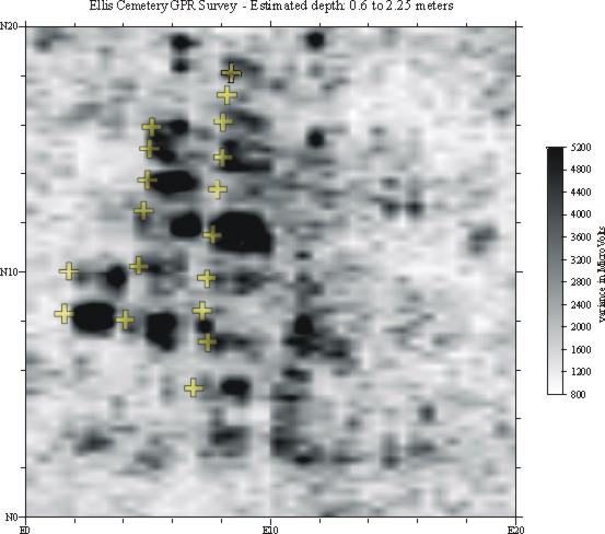
Planview Presentation of GPR data
GPR data are traditionally examined as profile maps of individual transects. Time-slicing is a technique for constructing planview maps of an area isolating specific depth ranges. This not only makes interpretation of the data in the horizontal plane much more intuitive, but also allows us to isolate specific depths (or more properly, the two-way travel times of reflected waves) for examination. Data for time-slice analysis must be collected systematically at closely-spaced (generally 50cm) transect intervals.
Electrical Resistance Survey
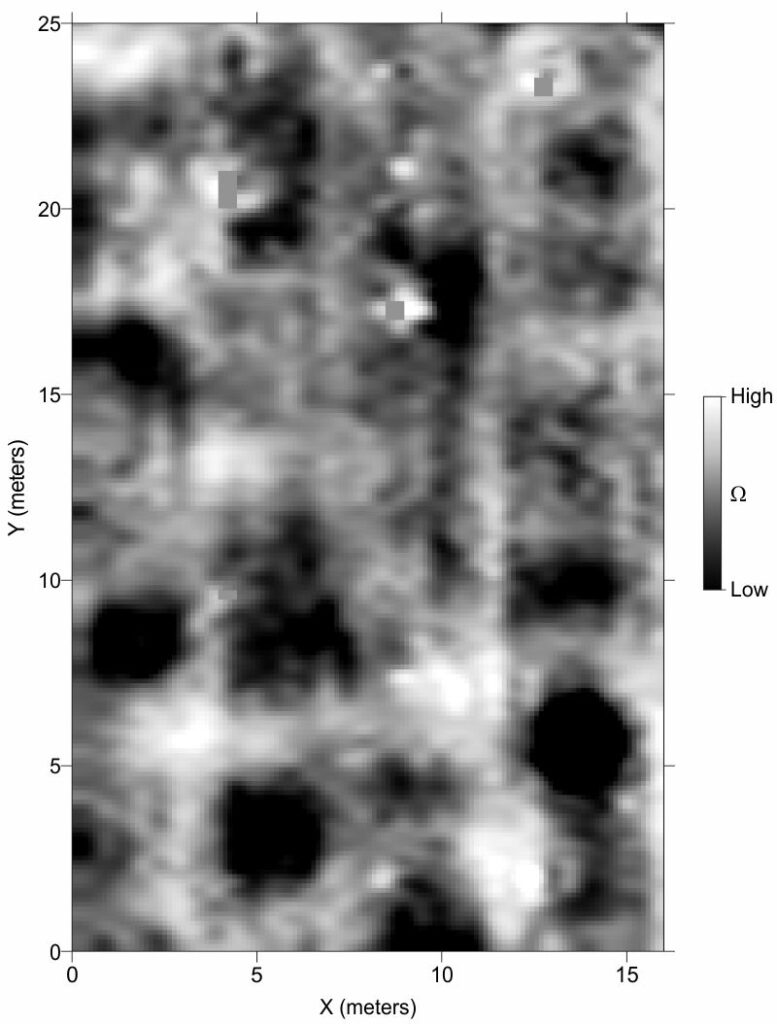
Electrical resistance survey can be very effective for mapping cemetery patterning. It is useful in a broad range of conditions, and often excels in clay-rich soils where GPR is ineffective. In historic cemeteries it can map the disturbed soils of grave shafts, and also landscape elements defining the cemetery. Precontact burial practices were very diverse, but a range of features may be detectable. In particular, burial mounds (even leveled) and pit features may be mapped.
Although resistance methods are more limited than GPR in their ability to detect low-contrast features at great depth, they may detect patterning cused by the disturbed soils within grave shafts. Resistance survey can be a valuable adjunct, even when conditions are favorable to GPR survey. Where site conditions (such as clay or silt soils) limit the effectiveness of GPR, resistance survey may be the principal survey method.
Graveshafts may appear as either high-resistance or low-resistance anomalies, and may appear as both within the same cemetery. Small-scale variance and anisotropy are also possible indicators of disturbed soils. Optimization of resistance methods for grave detection is a subject of ongoing research by Archaeo-Physics personnel.
Magnetic Survey
Magnetometers, usually magnetic field gradient instruments, can be very valuable for cemetery investigations. They are capable of very rapid and high-resolution mapping, and can detect a great range of feature types and materials. Magnetic survey is often the principal method for investigating precontact mortuary sites, and can be very useful in historic contexts as well.
Magnetometers can be very effective, but must be used judiciously. In many cases, igneous rock (as monuments or occurring naturally) and ferrous metal dominate the magnetic environment, obscuring more subtle patterning. In other cases these highly magnetic materials are buried below the surface and are indicators of cemetery patterning: Steel or iron in caskets, coffins or vaults, grave markers that have subsided and buried themselves, brick monuments, gravel paths and roads, even plastic flowers that have degraded, leaving their wire stems.
Where igneous rock, metal, and brick are not present, magnetometers can detect more subtle anomalies caused by concrete or organically enriched, disturbed, or compacted soils.
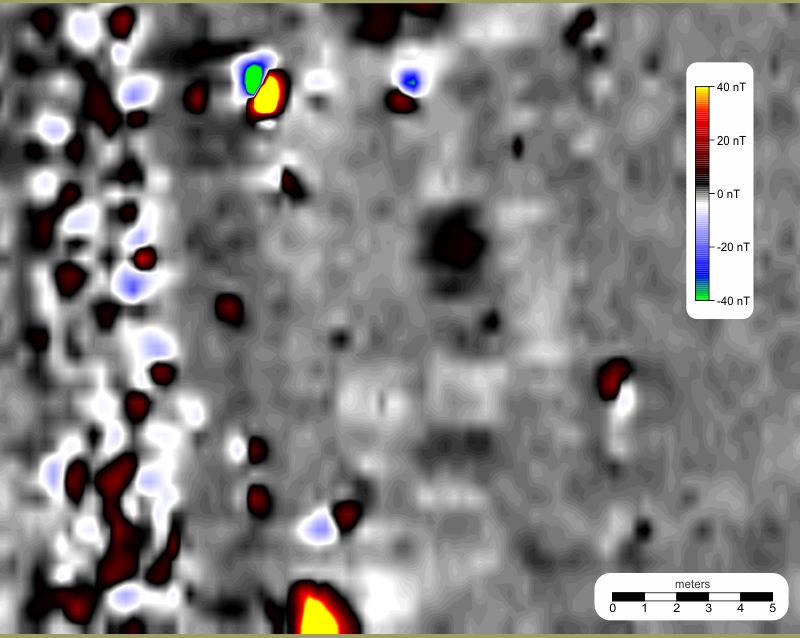
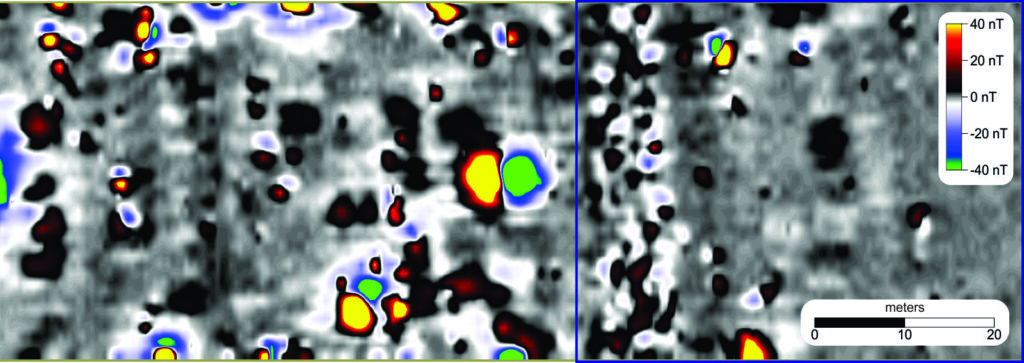
Magnetic survey results 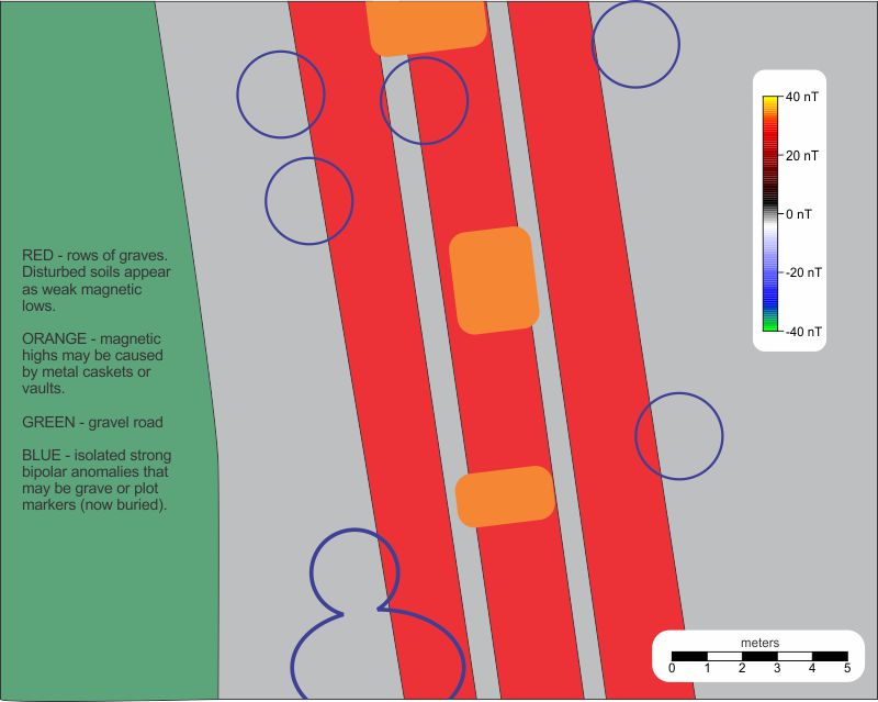
Interpretations
In the example above, there are no extant grave markers or surficial indications of burials. The interpretations are supported by multiple data sources, including limited subsurface testing, resistance survey results, and topographic and landscape features. The interpretations are supported by multiple data sources, including limited subsurface testing, resistance survey results, and topographic and landscape features.
Below is a larger area showing numerous similar expressions of burials. The area of the detail above is outlined in blue. This dataset represents a small portion of a much larger survey of the Wyandotte County Cemetery, Kansas City, KS. The cemetery is thought to contain many hundreds of burials, but only two visible grave markers.
Burials, whether historic or prehistoric, are often very difficult (sometimes impossible) to detect with geophysical methods. Ideally multiple geophysical methods are used in conjunction with careful mapping of surface features, historical research, and other data sources. Besides those discussed above, a number of other geophysical methods can be useful for mortuary investigations. These include magnetic susceptibility and electromagnetic (EM) conductivity survey, and minimally invasive methods such as penetrometer and soil chemistry testing.