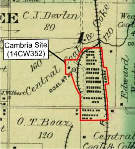
The Cambria site (14CW352) is an historic coal mining company town located in southeast Kansas. Iconsists of the remains of Mine No. 27 and the associated company town located near Pittsburgh, Kansas. The site was to be adversely affected by planned road construction. Prior to construction, a portion of the site was assessed using geophysical methods. A two-phased geophysical approach was developed to assess this very large site.
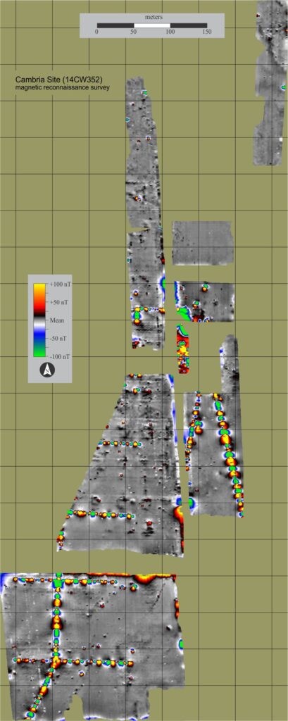
Phase I consisted of a very rapid but low-resolution magnetic survey to map large-scale intra-site patterning, and to target areas for additional high-resolution geophysical mapping. This reconnaissance survey was conducted over an area measuring approximately 1200 meters north-south and 400 meters east-west. The survey system was a Geometrics G-858 total field magnetometer integrated with a Trimble AG132 GPS guidance system. Data were collected in linear transects spaced at 2 meter intervals.
Phase II of the investigation targeted smaller areas of interest for high-resolution survey using electrical resistance and magnetic field gradient survey methods. Electrical resistance survey was conducted using a Geoscan Research RM-15 electrical resistance meter in twin-electrode configuration. Magnetic field gradient survey was conducted using a Geoscan Research FM-256 fluxgate gradiometer. High resolution data were collected at 0.5 meter transect intervals, providing much higher sample densities and better spatial control than the reconnaissance survey.
Ground truthing of survey results is important to validate (or invalidate) initial hypotheses, and inform further interpretation. Auger and shovel testing were performed on several geophysical anomalies, broadly confirming initial interpretations. The results of the investigation have yielded detailed knowledge concerning the location, patterning, and extent of buried resources at the Cambria site. These data were to be used to assist development of a comprehensive mitigation plan for the site.
The townsite has been cultivated since the early 20th century, and plowing appears to have heavily impacted much of the former living surface. Although there are no traces of the former town visible now, we know the approximate plan of the site from a 1906 plat map. This map of shows houses arranged along what appear to have been streets; 5 additional houses along the east side of the Frisco Railroad tracks; and 3 other houses to the west, north, and northeast of the camp. A 1901-1902 Crawford County directory indicates that Cambria had a population of 327 people.
Conclusions
GPS guided reconnaissance survey proved to be an effective and cost efficient method of mapping large-scale patterning across this unusually large site.
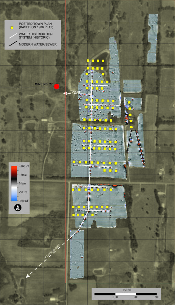
The most striking patterning – and perhaps the most surprising result of the geophysical survey, was the discovery of a water distribution system for the community. Appearing as alternating magnetic highs and lows, the steel water pipes appear to be largely intact, and correspond well to the historically recorded layout of the town. The main water supply line leads uphill to the southwest from the survey area towards a nearby hilltop, presumably the site of a tank or reservoir supplying the town.
The discovery of a water supply system was a surprise as the results of 1923 survey of over 700 mining camps and towns scattered around the country found running water in only 14% of households, and bath-tubs or showers in only 2.4% (1).
The geophysical survey identified numerous anomalies that were interpreted as possible sub-plowzone features. Initial testing has confirmed the presence of deep features at three locations. These features likely represent privy pits. Dozens more may be present in the survey data, but thus far remain untested. Geophysical survey proved to be a valuable method of locating these spatially small, but archaeological important features. Locating these features within the 48 hectare (~120 acre) project area would have otherwise been difficult, time consuming, and expensive.
This page is based on: Jones, Geoffrey, and David Maki. 2010. Geophysical Investigations at the Coal Mining Townsites of Cambria and Dunkirk. Archaeo-Physics Reports of Investigations #151. Minneapolis, MN.