Investigating precontact burned rock features in southeast Kansas
The Eastep site (14MY388), is a multicomponent Late Archaic (1500BC-500BC) and Woodland Period (500BC-1000AD) site on the Verdigris River in southeastern Kansas. Previous archaeological investigations had discovered several burned rock features – a relatively common, yet poorly understood feature type in this region. Although assumed to be associated with food processing, their specific function has been the subject of speculation. To better understand this feature type would illuminate questions of subsistence and settlement patterns at a time of incipient agriculture and sedentism.
Eastep was selected as the subject of the 2010 Kansas Archeology Training Program (KATP) field school. Research questions to be addressed included:
- What is the function of burned rock features in the Late Archaic?
- To what degree was plant cultivation a part of subsistence in the Late Archaic?
- What types of habitation structures were used during the Late Archaic and Woodland Periods?
- What were the environmental conditions during the time of occupation?
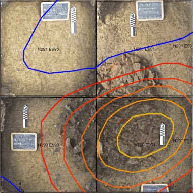
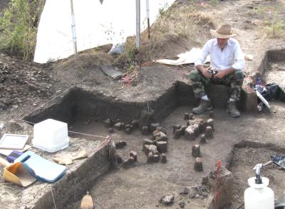
An excavated burned rock feature at the Eastep Site, with the associated magnetic anomaly shown as a contour overlay. Note the strong magnetic high (yellow/red) with a weaker low (blue) to the north, diagnostic of an in-situ burned feature. The magnetic high was correlated with high values in resistance data (not shown here), which together suggested a high concentration of burned rock. This feature is located at approximately north35/east40 on the geophysical maps below. The image of the excavated surface is a GIS mosaic assembled from georeferenced excavation photos.
Prior to the KATP field school excavations, Archaeo-Physics performed magnetic and electrical resistance surveys over a portion of the site. The most important target of the geophysical surveys were burned rock features, because of their relevance to the research questions. Numerous anomalies in the geophysical data were interpreted as burned rock features – an interpretation broadly confirmed by coring and excavation.
Magnetic survey results
Magnetic gradient survey was the principal geophysical survey method. Because heat can permanently alter the magnetic properties of minerals in rock and soil, magnetic surveys are often very effective for mapping burned archaeological features. Magnetic survey is also very rapid – therefore cost-effective – and can detect a wide range of other archaeological feature types.
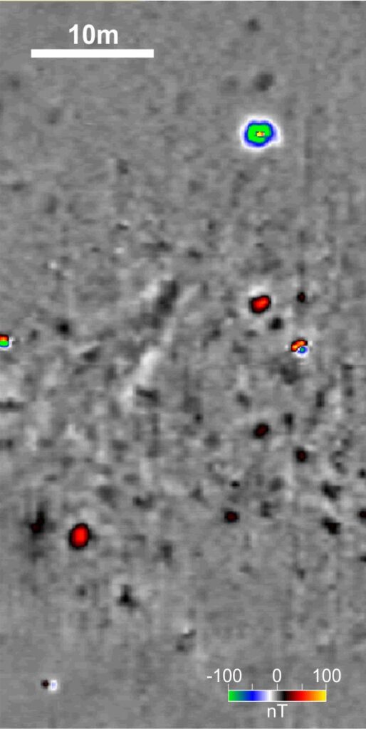
Magentic survey 
Magnetic survey interpretations
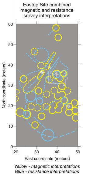
The images above show the magnetic survey results (left) and interpretations (right). Most of the anomalies that are circled are suspected to be hearths and burned rock features, generally appearing as roughly circular magnetic highs. Based on experience at other sites, these thermal features were expected (and later found) to be very large and intensely burned. Additionally, weaker and less defined magnetic highs were suspected to be middens or concentrations of organically enriched or burned material, although these have not been as thoroughly tested. Small but very strong anomalies (not marked) are caused by modern metal. It will be noted that suspected features are fewer in number and weaker in the northern half of the survey area; many features may be present in this area, but are less detectable because the occupation surface is more deeply buried. Numerous magnetic anomalies similar to those indicated are present, although more weakly or poorly defined; these may express cultural features. North-south striations visible in some areas are caused by modern plowing. Preliminary testing by coring is indicated in white. Excavation by the KATP field school is shown in red. A yellow circle indicates the burned rock feature shown at the top of this page.
Electrical resistance survey results
Based on the results of the magnetic survey, a smaller area was selected for resistance survey. Although in itself less effective than magnetic survey at this site, the results of the resistance survey nevertheless are useful and are complementary to the magnetic data. Each method was able to detect phenomena not detected by the other. In combination, the two methods provide more insight into physical composition and possible archaeological significance of suspected features.
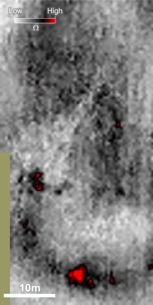
Resistance survey 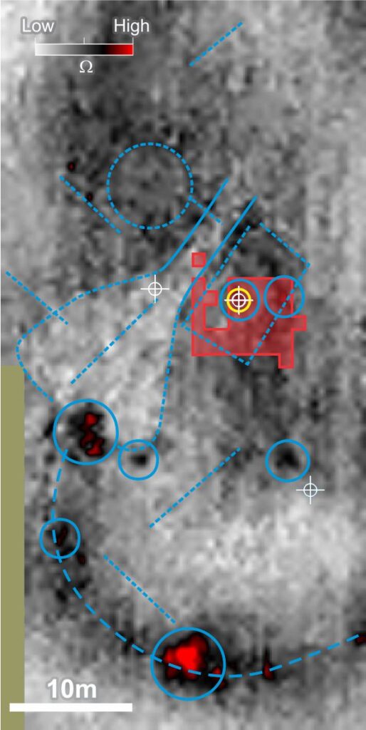
Resistance survey interpretations
In resistance survey data, high values may express concentrations of rock (whether cultural or natural). Resistance lows can result from organic enrichment or compaction. Very faint linear anomalies may result from historic/modern agricultural practices, but might also express prehistoric features such as wall trenches. Possible midden and architectural features suggested in resistance data remain largely unconfirmed by subsurface testing and excavation. North-south striations visible in some areas are caused by modern plowing. Preliminary testing by coring is indicated in white. Excavation by the KATP field school is shown in red. A yellow circle indicates the burned rock feature shown at the top of this page.
The combination of methods was very effective. Each method was able to detect phenomena not detected by the other. In combination, the two methods provide more insight into physical composition and possible archaeological significance of suspected features. In some instances there are clear correlations between the datasets, as well as very similar distributions of suspected features.
Initial testing, or ground truthing of preliminary interpretations was performed in conjunction with the geophysical fieldwork. Several auger tests were performed on suspected features, all of which yielded cultural materials such as burned rock, charcoal, bone, and stained soil. Auger testing of an adjacent non-anomalous area (not shown) showed an apparently natural soil profile.
The 2010 KATP field school
Under the direction of John Tomasic of the Kansas State Historical Society, The field school was able to target an area of high archaeological potential, known to contain at least one confirmed burned rock feature. The field school excavated 44 of the 6000 square meters covered by the geophysical survey, which included two large hearth features containing burned rock and the surrounding living surface.
GIS integration
Excavation drawings and photographs produced during the 2010 fieldwork were georeferenced for use in a geographic information system (GIS). Using GIS not only facilitated the creation of layered excavation maps, but also enabled integration of many different types of data. Artifact distributions (from surface collection as well as excavation), archaeological features, topography, and geophysical data were integrated using GIS, allowing analysis and visualization of relationships within and between these data layers. GIS was very useful in making precise correlations between excavation and geophysical data, providing insights to better interpret geophysical data from unexcavated parts (the vast majority) of the site. Another insight gained through GIS analysis was the relationship between mussel shell and heath features, suggesting patterns of social use of the hearth and food consumption reflected in the discard of shells.
Radiocarbon dates
Because burned features are detectable by magnetometry, datable carbon can often be located based on survey results. Dates obtained from the Eastep site are consistent with the Late Archaic – Woodland identification previously based on artifact typology.
Pending analyses
Much of the analysis of excavation data is in progress. The results of these analyses will undoubtedly shed light on questions of subsistence, settlement patterns, and trade in the Terminal Archaic and Early woodland periods:
Lipid analysis of residues on rocks to determine the types of foods that may have been processed in burned rock features.
Ethnobotanical analysis of plant remains recovered during excavation
Vertibrate faunal analysis of bones recovered during excavation.
Mussel shell Analysis, which can determine the season of occupation.
Lithic Analysis of stone tools and debitage can provide indications of activity at the site. Determining the sources of lithic materials with X-ray fluorescence can give indications of trade, travel, and long-distance relationships among Ancient Native Americans.
For more information on archaeology at Eastep see: The Eastep Site Revealed (Kansas Preservation, Fall 2010) by John Tomasic.
This page is based on: Geophysical and Archaeological Investigations of Burned Rock Features in Southeast Kansas (by Geoffrey Jones (Archaeo-Physics) and John Tomasic (Kansas State Historical Society)). Presented at the 2010 Midwest Archaeological Conference, Bloomington, Indiana, October 21 – 24, 2010.