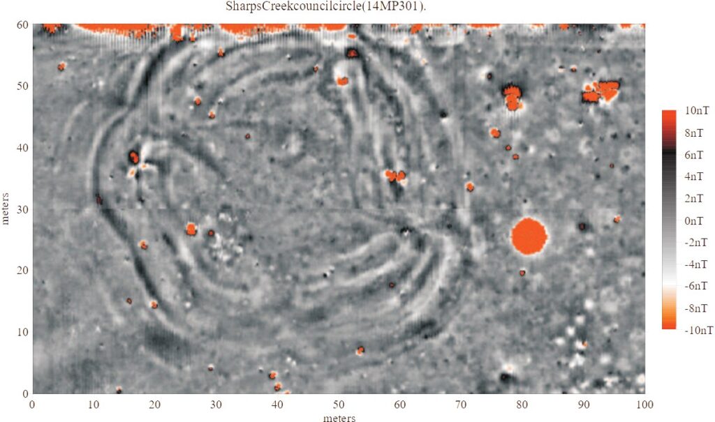
The imagery below present the results of a magnetic gradiometer survey of a proto-historic Native American council circle at the Sharps Creek site (14MP301), located in central Kansas, USA. The investigation was made possible through funding by the Kansas State Historic Preservation Office. Fieldwork was completed in the spring of 2007, with assistance from the Kansas Historical Society, Archeology Office. Earthworks and other archaeological features appear in these data as both positive and negative anomalies. The image may be viewed in alternate (inverted) color scales to better emphasize different anomalies and patterning. Hearths and other thermal features typically appear as magnetic highs, while pits, houses, postmolds, and other features may be expressed as either positive or negative anomalies. Stronger values (plotted in orange) are likely to express ferrous metal.
Project Background
Sharps Creek is a late ceramic period site located in McPherson County, central Kansas USA. The site is part of the Little River focus, which, along with the Lower Walnut focus, comprises the Great Bend aspect of Central Kansas. Radiocarbon dates from Great Bend sites date between A.D. 1450 and 1700. The sites are generally accepted as ancestral to the Wichita, a Native American group living in Oklahoma and Texas at the time of contact with French traders during the 18th century. Lees (1990, 1992) has suggested that Little River focus village sites may be tied to conquistador Francisco Vasquez de Coronado and his search for Quivira, the legendary city of gold. The presence of limited quantities of European artifacts at Great Bend Aspect sites such as chain mail and iron axe heads appears to support a connection with early Spanish exploration (Wood, 1998).
Among the Little River focus sites, five are distinctive in that they contain the remains of unusual structures called council circles. Council circles occur near the center of these sites, and previous excavations have suggested they consist of a central patio surrounded by four semisubterranean structures. The function of the council-circles is unclear. Waldo Wedel (1967) has suggested they may be ceremonial structures, possibly associated with solstice observations. Recent analysis suggests that many non-local artifacts occur exclusively or primarily within council circles, implying the structures were occupied by political and/or ritual leaders of the Little River focus peoples (Vehik, 2002). Other archaeologists leave open the possibility that the council circle earthen works served a defensive role (Hollinger, 2005).
The geophysical investigation was performed by Archaeo-Physics, LLC under the direction of Dr. Robert Hoard of the Kansas State Historical Society. The investigation utilized magnetic field gradient survey at very high data sample densities (32 samples per square meter), with the objective of mapping buried archaeological resources at the site. Magnetic survey was conducted over a 100 m x 60 m area. The geophysical survey grid encompassed most of the council circle, although a small portion of the northern edge of the circle was not surveyed due to the presence of a barbed wire and electric fence.
Conclusions
The magnetic field gradient survey data have revealed a complex earthenworks structure with numerous internal and external features. The main feature appears to be some 60 meters in diameter and may be described as a complex circular or oval shape with four or more lobes. The outer limits of the feature appear as concentric bands of positive and negative signal. There are approximately four to five of these bands. It is not clear whether these bands represent re-building events, contraction/expansion of the feature over time, or are part of the original feature plan. The “central patio ” of the feature is devoid of this banding, but does contain numerous anomalies that appear to represent internal archaeological features. Many anomalies are visible outside the main structure as well. These anomalies appear to represent archaeological features external to the council circle. In summary, the high-resolution magnetic imagery have revealed a surprisingly intricate feature that is more complex than previous invasive explorations had suggested.
Future Research
Several additional non-destructive technologies such as electrical resistance, ground penetrating radar, or electromagnetic susceptibility could be utilized to increase our understanding of this complex feature. Because each of these methods responds to contrasts in different material properties these additional data would be complementary rather than redundant.
References:
Lees, William B (1990). Evidence for Early European Contact with the Witchita in Kansas. Paper presented at the Conference on Historical and Underwater Archaeology, Tucson, Arizona, January, 1990.
Lees, William B (1992). The Relationship Between Proto-Witchita Sites in Rice and McPherson Counties. Paper presented at the 50th Annual Plains Anthropological Conference, Lincoln, Nebraska.
Vehik, Susan C. 2002. Conflict, Trade, and Political Development on the Southern Plains. American Antiquity, 67(1), 37-64.
Wood, Raymond W. 1998. Archaeology on the Great Plains. University of Kansas Press, Lawerence, Kansas.
Hollinger, Eric (2005). Conflict and Culture Change in the Late Prehistoric and Early Historic American Midcontinent. Unpublished PhD Dissertation. University of Illinois at Urban-Champaign.
Wedel, Waldo (1967). The Council Circles of Central Kansas: Were They Solstice Registers? American Antinquity 32, 54-63.